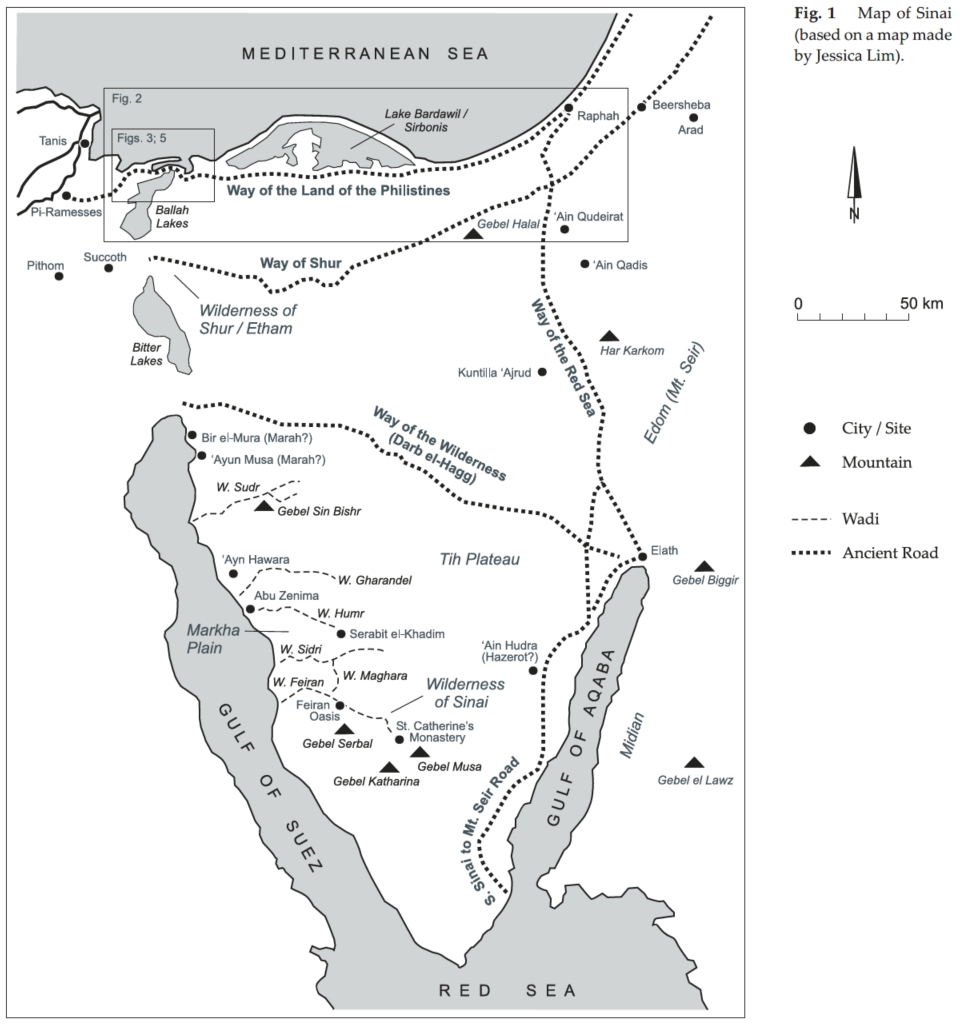
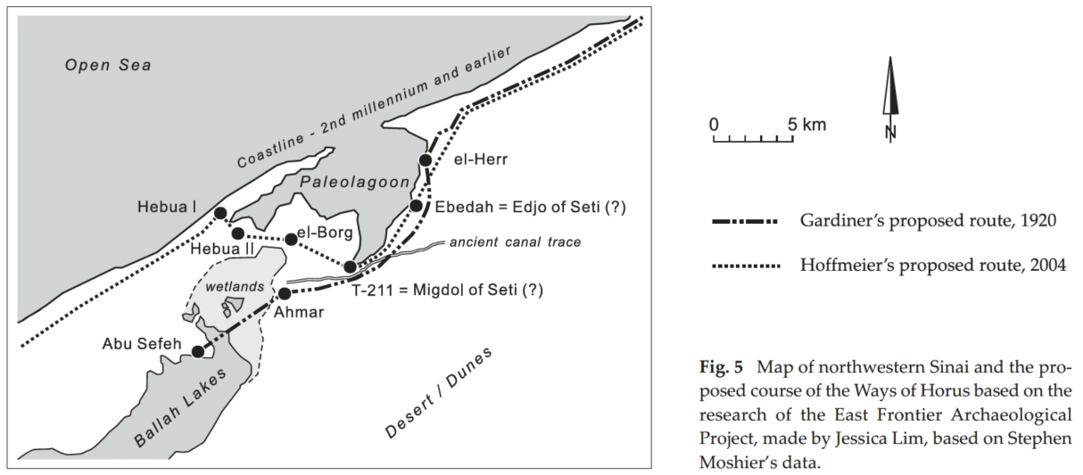
This post is a summary by Claude.ai of the paper by Moshier & Hoffmeier: “Which Way Out of Egypt? Physical Geography Related to the Exodus Itinerary“ (in Levy, Schneider & Propp, eds., Israel’s Exodus in Transdisciplinary Perspective, 2015, ch. 8). A PDF copy is in the James Hoffmeier directory in DropBox. Scroll down to see his two route maps from another paper. See also the post at this site about the alternate spellings of Yam Suf.
Purpose and Method
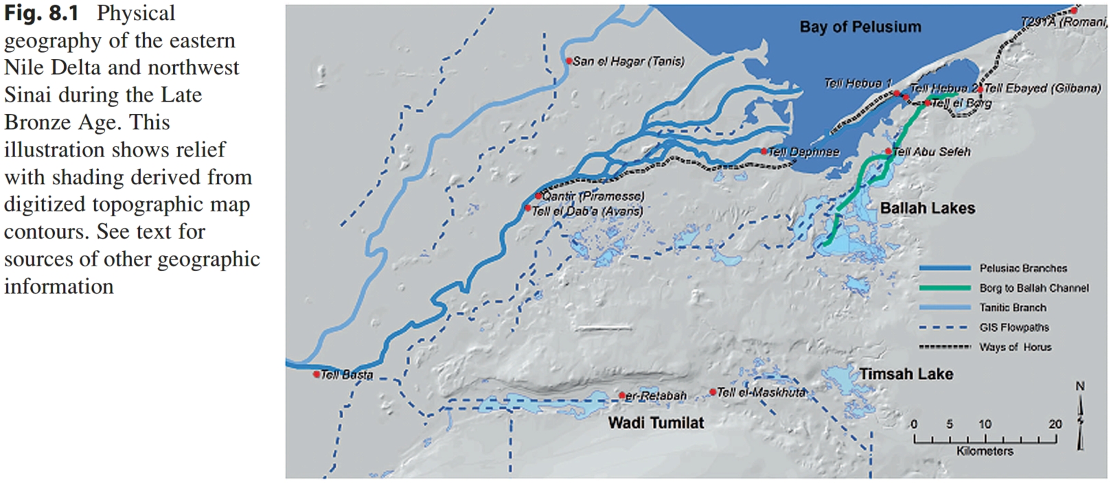
The authors reconstruct the natural geography of the eastern Nile Delta and northwest Sinai during the Late Bronze Age (c. 3,500–3,200 years ago) to give the Exodus geographic references a physical setting. Bible maps typically show modern coastlines, rivers, and lakes, which the authors argue misleads, since the landscape has changed substantially. Their map (Fig. 8.1) combines three kinds of evidence:
- Cartography: a GIS terrain model built from vintage Survey of Egypt topographic maps (1900–1945), made before heavy modern development and before agricultural and urban alteration.
- Satellite imagery: declassified CORONA spy photographs (1960–1972) used to spot ancient coastlines and river channels (Fig. 8.2).
- Hydrologic modeling: GIS flow-accumulation analysis to test whether water would flow along suspected ancient Nile branches. The authors present this only as a plausibility check.
Locations of Nile branches and the coast also draw on earlier work by Bietak, Marcolongo, Coutellier and Stanley, and Moshier and El-Kalani.
Key Findings on Paleogeography
- The Pelusiac branch of the Nile flowed northeast across the eastern delta during the Bronze Age. Up to four sub-distributaries branched off northeast of Tell el-Dab’a (Avaris), with dominant flow shifting westward over time.
- The Mediterranean coast sat along the structural “Pelusium Line” for roughly 1,500 years through the Late Bronze Age. Beach accretion finally closed the Pelusiac branch’s connection to the sea in the early AD 800s.
- Low Nile discharges from about 1200 BC probably began silting up the Pelusiac channels, and westward tilting of the delta may have contributed to their abandonment.
- Fieldwork at Tell el-Borg (1999–2008) revealed a previously unknown early Nile branch running from the Ballah Lakes northeastward to Tell el-Borg, apparently emptying into a lagoon behind a barrier strand.
- The Ballah Lakes and the chain of wetlands along the present Suez Canal Zone follow rift-related crustal extension. The Ballah depression flooded annually, even in recent centuries. Qantara, whose Arabic name means “bridge,” marks a narrow land bridge between the delta and Sinai.
- Wadi Tumilat probably reflects older (Pliocene–Pleistocene) drainage and is known to have flooded end to end in high-flood years. Necho II and Darius I later cut canals there.
Implications for the Exodus Toponymy
The authors work through the itinerary place by place:
- Rameses is Piramesse, identified with Qantir (Gardiner, Habachi).
- Pithom is placed at Tell er-Retabeh in Wadi Tumilat, likely Pi-Atum.
- Succoth is Egyptian tkw, tied to Wadi Tumilat and Tell el-Maskhuta.
- Etham is probably at the eastern end of Wadi Tumilat, possibly near Lake Timsah. Its name, like Pithom’s, preserves the god Atum.
- Route logic: the initial movement toward Wadi Tumilat would avoid the militarized coastal “Ways of Horus” (Exod 13:17) and aim for the southern Way of Shur. A sensible overland route would run south along the Pelusiac channel toward Bubastis, not straight across the swamps and sandy plateau.
- Migdol is a fortress on the Ways of Horus. The “turning back” of Exodus 14:2 would put the Israelites in the Ballah Lakes zone, a fortified frontier that included Tjaru (Hebua I and II) and Tell el-Borg.
- Yam Suph: Lake Timsah would be a logical candidate but doesn’t fit the narrative’s “turning back” to a different body of water. The authors follow Gardiner and Bietak in linking Egyptian p3 twfy (a region of freshwater, reeds, and rushes) with Hebrew yam sûp, and they identify it with the Ballah Lake system. They identify Egyptian p3-shi-Hor (biblical Shihor) with the eastern lagoon.
Conclusion
Their work supports Gardiner’s and Bietak’s identifications, and the authors argue the Exodus geographic references should be read against this reconstructed ancient landscape.
Critical Notes
The GIS flowpaths are explicitly only a plausibility check, and many identifications (Etham, Pi-Hahiroth, Baal Zephon) remain tentative or undiscovered.
The paper is a short methodological and synthetic chapter. The Ballah Lakes = yam sûp identification rests largely on the linguistic argument and on the paleogeography fitting a particular reading of the itinerary. The geology shows where water bodies existed, not that the Exodus narrative refers to them.
The authors work from the premise that the itinerary reflects real Late Bronze Age geography. That is a historical assumption the paper doesn’t test, and critical scholars would contest it.
From James K. Hoffmeier & Stephen O. Moshier’s paper “A highway out of Egypt”: The main road from Egypt to Canaan. See the pdf file A_Highway_out_of_Egypt_the_Main_Road_fr.pdf in Hoffmeier’s directory in DropBox.