From BAR Mapping Troy’s Luwian Context
In a paper published in the journal Nature Scientific Data, an international team from the Luwian Studies Foundation provided the most up-to-date map of Middle and Late Bronze Age (c. 2000–1200 BCE) Luwian settlements ever catalogued, which includes ancient Troy. The study, comprising 483 settlements, illuminates the cultural landscape around Troy and challenges long-standing scholarly assumptions. Alongside the scientific article, the team also published an interactive settlement map that provides an incredible wealth of information on each site, including archaeological and chronological data.
The interactive map shows the location of a total of 483 Middle and Late Bronze Age (2000–1200 BCE) settlement sites larger than 100 meters in diameter in the western part of the Republic of Türkiye that have been catalogued by Luwian Studies until March 2025.
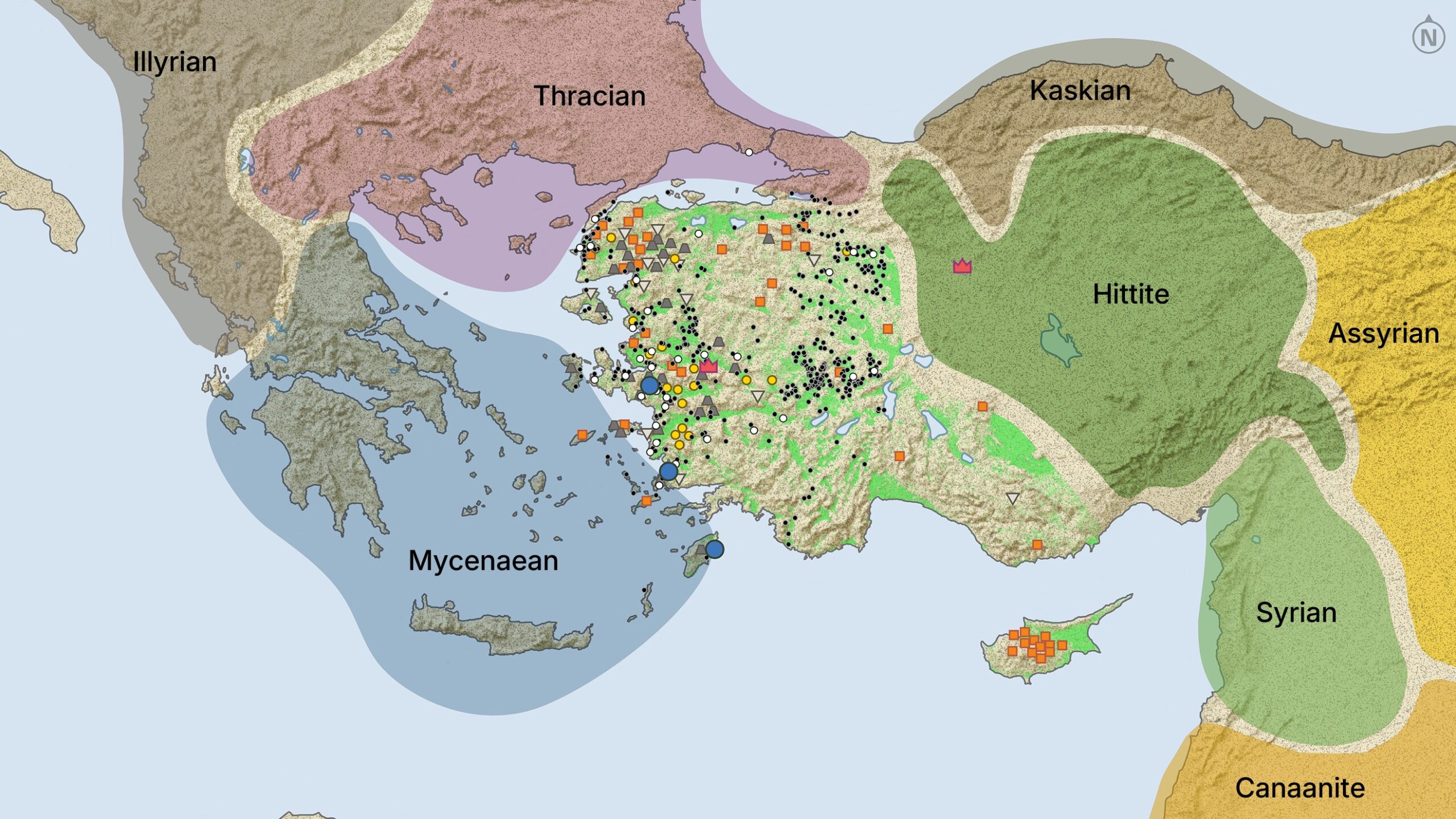
Go to the link above for the interactive version of this map. Note in the above map that the Luwain territory is not labeled and has black dots and other graphics.
The ChatGPT summary is as follows.
Here is a summary of the attached article “Mapping Troy’s Luwian Context” by Nathan Steinmeyer, based directly on the text you provided. Citations point to the file excerpts.
Summary
The article explains that although Troy is popularly linked with Homer’s Iliad or modern films, its real historical setting is the little-known Luwian cultural world. The Luwians occupied most of western Anatolia during the Bronze and Iron Ages and were neither Greek nor Hittite. Troy itself—known in Hittite sources as Wilusa, related to Greek Ilios—was one city among many in this broader Luwian sphere.
A new study published in Nature Scientific Data created the most comprehensive map to date of Middle and Late Bronze Age Luwian settlements (about 2000–1200 BCE). The project catalogued 483 sites, including Troy, and makes available an interactive map with archaeological and chronological data for each location. The research team participated in many excavations and surveys and produced over 400 scholarly publications on these sites. Their findings challenge the old view that western Anatolia was merely a borderland caught between Hittite and Mycenaean power. Instead, the region reveals a dense and distinct cultural landscape with its own traditions and political identities.
The article highlights material culture—such as a distinctive vessel from Seyitömer Höyük and the tiny bronze seal from Troy inscribed with Luwian hieroglyphs—underscoring Troy’s participation in this non-Greek, non-Hittite world. According to Eberhard Zangger, President of the Luwian Studies Foundation, Troy is “the epitome of a Luwian town.” But he also stresses that modern labels (“Hittite,” “Mycenaean,” “Luwian”) oversimplify ancient identities; people of the time identified mainly with their immediate city-states rather than large cultural blocs. The region consisted of many tribes and groups who shared certain linguistic and cultural features but did not see themselves as part of a single uniform civilization.
Overall, the study reframes Troy not as an isolated site defined by Greek legend but as a major city embedded in a rich, complex western Anatolian (Luwian) environment, now mapped more comprehensively than ever before.
