In John Kloppenborg’s directory in Dropbox is the paper titled LUKE ON JESUS, PAUL AND CHRISTIANITY: WHAT DID HE REALLY KNOW? Edited by Joseph VerHeyden and John S. Kloppenborg. Below is Claude.ai’s summary of the paper. The paper and this summary list many examples of Luke’s lack of geographical knowledge of the interior of the Levant. Whereas he has good understanding of the coast, and apparent firsthand knowledge for the Aegean. In addition, Kloppenborg says Luke has an insistence on connecting Jesus, the apostles, and Paul with cities rather than the countryside. Below is Claude.ai’s summary of the paper.
Luke’s Geography: Knowledge, Ignorance, Sources, and Spatial Conception John S. Kloppenborg (University of Toronto)
Core Argument and Framework Kloppenborg investigates what Luke actually knew about the geography of the Mediterranean world he narrates, and how that knowledge functioned in his “spatial imaginary.” He distinguishes three kinds of spatial knowledge: (1) place-name knowledge (knowing a name exists), (2) relational/cartographic knowledge (knowing how places relate to one another), and (3) local knowledge (intimate, on-the-ground familiarity). His thesis has three parts: Luke’s topographical competence varies enormously by region; the sources behind that knowledge differ accordingly (inherited traditions from Mark/Q, versus itineraries and maps for the coast, versus apparent firsthand knowledge for the Aegean); and the resulting spatial imaginary encodes particular social and ideological values—chiefly, an insistence on connecting Jesus, the apostles, and Paul with cities rather than the countryside.
I. Interior Palestine: Case Studies in Ignorance
- Mary’s journey to Elizabeth (Luke 1:26–39): Mary travels from Nazareth (called a polis) to an unnamed polis in the Judean hill country as though it were a simple visit, when the trip (via the Jordan Valley and Jericho) would take roughly four days on foot—an implausible solo journey for an unaccompanied woman. Luke’s interest is theological (linking Jesus’ and John’s families), not geographical accuracy.
- Luke’s overuse of “polis”: Luke calls Nazareth, Bethlehem, Capernaum, Nain, and Arimathea poleis (cities), none of which were cities in the first century. Kloppenborg connects this to Luke’s apologetic aim of countering critics like Celsus, who mocked Jesus and his followers as rustic yokels; Luke instead ties Jesus and his movement to the prestige of cities.
- The Gerasene demoniac (Luke 8:26–39): Luke’s redactional phrase “opposite Galilee” excludes Gerasa (a real polis of the Decapolis but ~30 km from the Sea of Galilee) as the story’s setting, yet Luke retains the name anyway—producing a geographically incoherent location. He also changes Mark’s reference to the demoniac preaching “throughout the Decapolis” to “throughout the entire city,” compounding the confusion.
- Bethsaida and the feeding miracle (Luke 9:10–17): Because Luke omits a large block of Markan material, he borrows Mark’s mention of Bethsaida (now labeled a polis) as the site of the feeding miracle, yet retains Mark’s description of it as a “deserted place” surrounded by villages—a contradiction Kloppenborg attributes either to “editorial fatigue” or to Luke imagining Bethsaida as a metropolis with surrounding villages.
- The Transfiguration: Since Luke has omitted Mark’s reference to Caesarea Philippi, the transfiguration is left to occur on an unspecified “mountain” near Bethsaida—even though no mountains exist near Bethsaida’s actual location at the south end of the Huleh valley.
- The Travel Narrative (Luke 9:51–18:14): The most extensive case study. Luke has Jesus deliver “woes” against Galilean towns (Bethsaida, Chorazin, Capernaum) while narratively far to the south; sets stories in Samaria (the Good Samaritan, the Samaritan leper) while also implausibly placing Mary and Martha’s village, Pharisaic controversies, and a “woe against Jerusalem” in the same region; and has Jesus circle back to being “between Samaria and Galilee” (17:11) despite supposedly making steady progress toward Jerusalem for chapters. Kloppenborg cites McCown’s classic 1938 judgment that Luke shows “complete ignorance or…complete indifference” to geography here. Luke also fails to indicate the roughly 1,200-meter ascent from Jericho to Jerusalem, using the stock LXX phrase “go up to Jerusalem” rather than any real topographic knowledge.
II. Jerusalem and the Temple: A Mixed Case
Luke shows slightly better—but still inconsistent—knowledge of Jerusalem:
- He knows (or assumes) the incense altar in the Herodian temple was not visible from the public court (1:10–11, 21–22).
- In Acts, he twice mentions the “Beautiful Gate” (3:2, 10) and “Solomon’s Portico” (3:11; 5:12)—the latter likely invoked to associate the Jesus movement with philosophical schools (like the Stoics) rather than out of real topographical interest.
- He mentions a “synagogue of the Freedmen” and Cyrenians/Alexandrians (Acts 6:9), probably drawn from a source, but his real interest lies in setting up later conflict with Paul’s opponents from Cilicia and Asia.
- Most tellingly, Luke’s account of Paul’s arrest (Acts 21:27–40) correctly reflects that non-Jews were barred from parts of the temple, and describes soldiers “running down” from the Antonia fortress to the temple platform—accurately implying knowledge of the staircase connecting the two, a detail Kloppenborg notes could derive from Josephus rather than personal knowledge.
- Conversely, Luke shows no awareness of the topography connecting the Mount of Olives, Gethsemane, and the high priest’s house during the arrest and trial narratives.
III. The Emmaus Problem (Luke 24:13). An extended case study: Luke places Emmaus “sixty stadia” from Jerusalem, a figure disputed in the manuscript tradition (Sinaiticus reads 160 stadia). Kloppenborg reviews four candidate sites—Motza/Colonia, Kiriath-Yearim (Abu Ghosh), el-Qubeibeh, and Emmaus-Nikopolis—and concludes Emmaus-Nikopolis (actually ~160 stadia away, per Byzantine sources, Pliny, Ptolemy, and the Tabula Peutingeriana) is the intended site. This means Luke’s “sixty stadia” is essentially a guess necessitated by his narrative (the disciples return to Jerusalem the same night), further evidence of his weak grasp of Judean topography.
IV. The Levantine Coast: Case Studies in Competence – Luke’s coastal geography, by contrast, is coherent:
- Philip’s road to Gaza and the Ethiopian eunuch (Acts 8:26–40): Philip’s route down the desert road to Gaza, then his reappearance at Azotus and travel north to Caesarea, matches known roads and Strabo’s description of the region as barren.
- Peter’s journey to Joppa and Caesarea (Acts 9:32–11:18): Peter’s movements from Jerusalem to Lydda to Joppa to Caesarea are geographically sound, and the different travel times for Cornelius’s messengers versus Peter’s larger party plausibly reflect two known coastal routes (a shorter seasonal road vs. a longer inland road through Antipatris).
- Paul’s return to Jerusalem and voyage to Rome (Acts 21; 23; 27): Paul’s itinerary (Miletus–Cos–Rhodes–Tyre–Ptolemais–Caesarea; later Caesarea–Antipatris–Caesarea–Sidon) consistently follows known roads and sea routes.
- The Judaea/Caesarea distinction (Acts 12:19; 21:10): Luke consistently describes people traveling “down from Judaea” to Caesarea, reflecting (per Josephus and Ptolemy) a real cultural/administrative distinction between the interior and the culturally distinct, historically “freed” coastal cities.
V. The Northeast Aegean: Local Knowledge. Three examples suggest Luke had genuine firsthand familiarity with this region:
- Sailing conditions (Acts 16:11–12; 20:6): The quick voyage from Troas to Samothrace and the much slower five-day return trip accurately reflect known seasonal wind patterns (per Robert Jewett’s research).
- Philippi as “first city of Macedonia” (Acts 16:12): Though technically inaccurate (Thessalonica was the actual capital), this reflects the kind of exaggerated civic pride typical of ancient cities—suggesting Luke picked up on local Philippian self-promotion rather than making a factual error from ignorance.
- Prayer by the river at Philippi (Acts 16:13): Unlike his usual pattern of having Paul enter a synagogue first, Luke here has Jews gathering by a river—a deviation Kloppenborg reads as reflecting actual local knowledge of Philippi’s lacking a synagogue building.
VI. Sources of Luke’s Knowledge Kloppenborg surveys the ancient geographic literature that could have supplied Luke’s coastal knowledge: periploi (sailing guides) like the Stadiasmus Maris Magni; itineraries and painted maps (itineraria picta) such as Agrippa’s map (displayed publicly in Rome); Strabo’s and Pliny’s geographies (both ruled out as direct sources due to poor fit); Ptolemy’s Geography; and especially the Tabula Peutingeriana, a Roman road map whose underlying data likely dates partly to the first or early second century. Kloppenborg shows that the coastal cities named in Luke-Acts match closely with those catalogued in Ptolemy and the Tabula, while inland Galilean/Judean villages (Capernaum, Nazareth, Nain, Gerasa, Bethany) are absent from these sources entirely—explaining precisely the pattern of Luke’s knowledge and ignorance. An appendix tabulates all relevant place names against Pliny, Ptolemy, and the Tabula Peutingeriana.
VII. Cartographic Knowledge as Socially Located (Theoretical Framework) Drawing on Henri Lefebvre’s theory that “social space is a social product” encoding ideology, Kloppenborg compares two ancient maps as interpretive lenses for Luke:
- The Tabula Peutingeriana: Emphasizes total connectivity—every city linked to every other by roads—projecting Roman imperial power and mastery over the oikoumenē.
- The Madaba Map (6th century): By contrast, centers Jerusalem and is organized around biblical/salvation-historical significance rather than route-accuracy, largely omitting roads.
Kloppenborg argues Luke’s spatial imagination resembles the Tabula’s model far more than the Madaba Map’s: it stresses the interconnectedness of cities (Jesus to Jerusalem; Peter, Paul, and the apostles to a network of assemblies across the Levant, Asia, Greece, and Rome), while erasing the rural countryside almost entirely. Supporting examples: shepherds in the infancy narrative must come “into the city” to worship the infant Jesus; the parable of the mustard seed is relocated from a field to a “garden”; the shepherd who finds a lost sheep “in the wilderness” returns straight to his house in town. This urban bias, Kloppenborg concludes, reflects Luke’s own social location and serves his larger apologetic and theological goal: presenting the Jesus movement as a civilized, urban, empire-spanning, and harmoniously interconnected phenomenon—summed up in Paul’s programmatic claim that “none of this was done in a corner” (Acts 26:26).
Maps currently available:
Tabula Peutingeriana
- The paper’s own link is live: Richard J.A. Talbert’s interactive map viewer, hosted by the Institute for the Study of the Ancient World at NYU — http://peutinger.atlantides.org/map-a/ (best option; zoomable, scholarly-annotated)
- Full-resolution scan from the Austrian National Library (the actual manuscript, Codex Vindobonensis 324): https://www.wdl.org/en/item/19199/ (World Digital Library) or search “Tabula Peutingeriana ÖNB digital”
Madaba Map The paper’s cited URL (christusrex.org) is no longer reachable directly, but an archived version exists:
- Archived ChristusRex site via Wayback Machine: https://web.archive.org/web/2019*/http://www.christusrex.org/www1/ofm/mad/index.html
- Wikipedia overview with a good composite image: https://en.wikipedia.org/wiki/Madaba_Map
- Annotated, searchable list of place-names on the map (adapted from the original ChristusRex content): https://topostext.org/work/788
[The following images were provided by Claude and are now part of this website’s data set.]
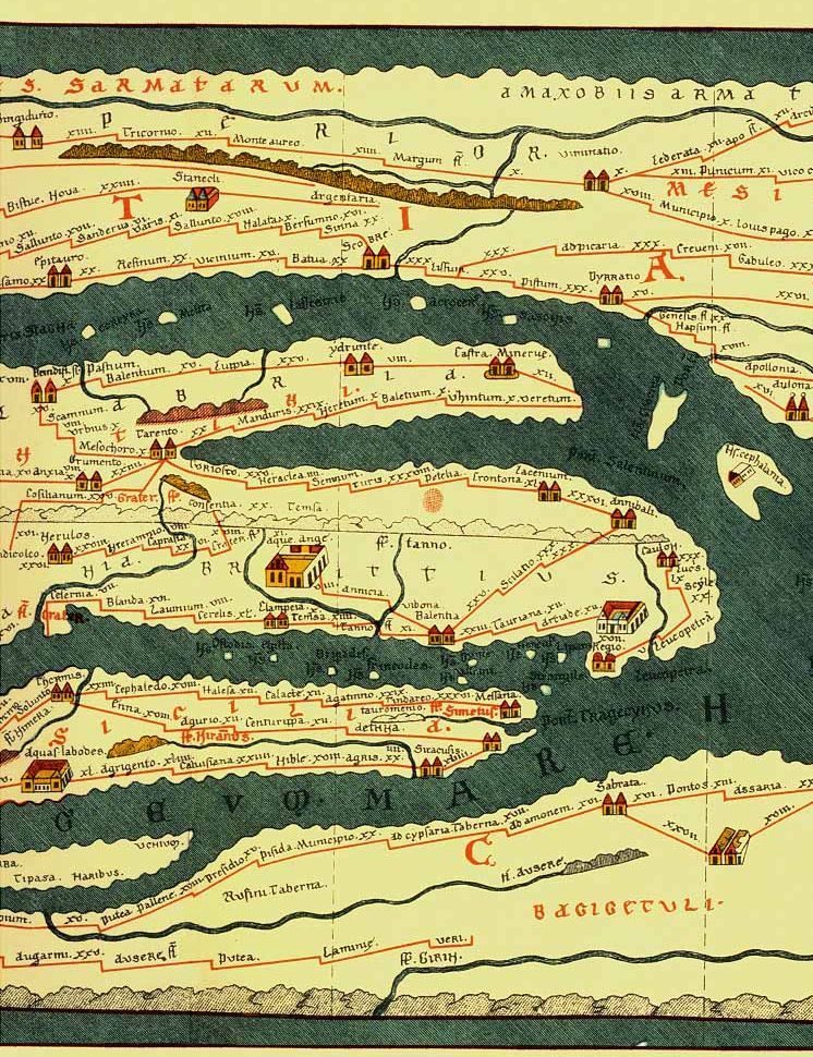
The Tabula Peutingeriana above shows the characteristic elongated, schematic style — the whole Mediterranean world is stretched into a narrow horizontal strip, with cities marked as vignettes and roads as straight connecting lines showing distances. This is exactly the “web of connectivity” Kloppenborg describes.

Now here’s the Madaba Map for comparison: Notice the contrast immediately: the Madaba mosaic is colorful, pictorial, and centers on the walled oval of Jerusalem with individual buildings (colonnaded streets, church domes) rendered in detail — there’s no attempt at consistent scale or a connecting road network the way the Tabula shows. It reads more like an illustrated pilgrimage itinerary of holy sites than a navigational tool, which is exactly Kloppenborg’s point: one map projects Roman administrative/military reach, the other projects sacred geography centered on salvation history.
