From ChatGPT
The Great Trunk Road near Nazareth in the time of Jesus
The Great Trunk Road in the Galilee during the first century CE was part of a much older international highway system that connected Egypt to Syria and Mesopotamia. In Roman times, this road system was maintained and integrated into the imperial network, but its origins go back to the Bronze Age and Iron Age trade routes.
It is most commonly identified with the route later called the Via Maris (“Way of the Sea”), one of the major highways of the ancient Near East.
Route of the Great Trunk Road through Galilee


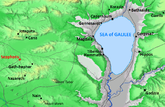
In the first century, the main trunk route ran:
- From Egypt along the Mediterranean coast
- Through the coastal plain of Canaan
- Inland at the Jezreel Valley
- Past Megiddo, a strategic crossroads
- Eastward across the valley toward the Sea of Galilee
- Then north toward Damascus
This inland segment of the route passed very near Nazareth.
Proximity to Nazareth
Nazareth itself was not directly on the trunk road, but it lay only a few miles from it:
- The road passed through the major administrative and commercial center of Sepphoris (Zippori), about 4 miles (6–7 km) northwest of Nazareth.
- From Sepphoris, the road continued toward the Jezreel Valley and the crossroads at Megiddo.
Because of this proximity:
- Nazareth was a small rural village off the main highway.
- Yet it was within walking distance of a major international route.
- This meant exposure to trade, Roman administration, soldiers, merchants, and travelers.
Many historians note that Sepphoris was being rebuilt by Herod Antipas during Jesus’ youth (early 1st century CE). Some scholars suggest that craftsmen from nearby villages, including Nazareth, may have found work there.
Why the road mattered historically
The Great Trunk Road/Via Maris was significant because it:
- Connected three continents: Africa, Asia, and Europe (through Mediterranean ports).
- Carried armies, traders, pilgrims, and officials.
- Made Galilee a culturally mixed and economically active region, not an isolated backwater.
This helps explain:
- The presence of Roman authority and taxation in the region.
- The diversity of populations mentioned in the Gospels.
- The strategic importance of towns around the Sea of Galilee.
Scholarly perspective
Historical geographers and critical scholars generally agree on this reconstruction:
- Richard A. Horsley and John Dominic Crossan describe Galilee as economically integrated because of these major roads.
- Jonathan L. Reed emphasizes that Sepphoris, near Nazareth, was a major urban center tied directly to the regional trade routes.
- Standard historical atlases (e.g., those by Barry Beitzel and Carta) map this inland segment of the Via Maris running past Megiddo and near Sepphoris.
Summary
- The “Great Trunk Road” in Galilee was the inland segment of the Via Maris.
- It ran from Egypt through the Jezreel Valley and north toward Damascus.
- It passed through Sepphoris, about 4 miles from Nazareth.
- Nazareth was not on the road but was close enough to feel its economic and cultural influence.
